Table of Contents
Land Acquisitions
Taranaki Botanical Garden Act 1876
This section gives an overview of the land acquired by the Park. It is not 100% complete. For a more detailed description see the NPDC 2004 Park Management Plan which details all the land acquisitions with title numbers and deed numbers.
The last act of Taranaki’s Provincial Council on JUNE 30, 1875, was to pass the Botanical Gardens and Public Recreation Grounds Bill 1875, which enabled public land to be utilised for recreation. It is widely assumed that the Bill allocated 39 acres of land, however, at the first Board meeting in August 1875 it was recorded that they were granted 47 acres. When the Bill went for approval to the Governor-General there were some issues, and he was advised not to sign it into law. After the Bill was amended it was passed by the new Colonial Parliament in September 1876 as the Taranaki Botanic Garden Act 1876. The new Act was comprised of 48 acres, 3 roods, 6 perches of land. Prior to September 1876 the Board had acquired more land some of which must have been incorporated into the new Act.

Taken from Carrington’s original relief map of New Plymouth.
Collection of Puke Ariki (Ref: ARC2004-287).
Superimposed is the area of the Recreation Ground defined in the Taranaki Botanic Garden Act 1876. This shows what the terrain was like when the trustees first acquired the land.
The Taranaki Botanic Garden Act 1876 (see page 251) defined the Recreation Ground showing it to be approximately 49 acres, made up of 109 quarter acre town sections, some areas of paper roads and some green areas such as Area L, M and X. An interesting aspect of the act is section 18 which stated that “The Governor may, on the petition of the majority of the members for the time being of the Board, or of two-thirds of the rate payers of the Borough of New Plymouth, dissolve the said Board, and on such dissolution the said lands vested by this Act shall be vested in the Borough of New Plymouth, and be managed by the said Borough as the Board is authorized to manage the said lands.”
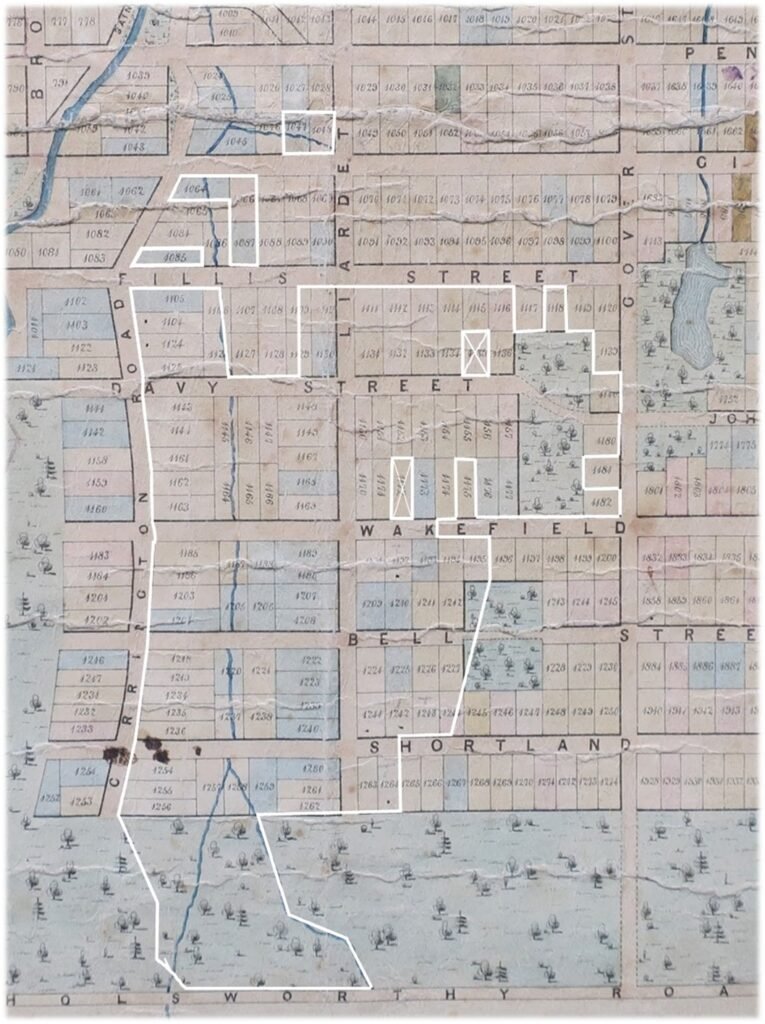
The original boundary of the Recreation Ground as defined by the Taranaki Botanical Garden Act 1876.
Base map: Carrington’s Plan of New Plymouth, 1842.
Collection of Puke Ariki (Ref: ARC2004-285).

This map is an overall picture of land acquisitions for Pukekura Park without Brooklands.
Turquoise line indicates the current boundary of Pukekura Park.
White numbered sections – original whole sections.
Yellow numbered sections – these sections were acquired later.
Section with numbers, half yellow and half white indicates a part section.
The map on the previous page shows the makeup of the Recreation Ground as far as the original southern boundary, which was the northern edge of Holsworthy Road. The turquoise line is the modern- day boundary of the Park.
Town sections with white numbers represent the original whole sections granted in the Taranaki Botanical Garden Act 1876. Two sections originally granted which do not appear on this map, 1047 and 1048 which are where the model train is situated on Gilbert Street.
Sections with yellow numbers were purchased later.
Section with numbers, where 2 digits are white, and 2 digits are yellow indicates a part section.
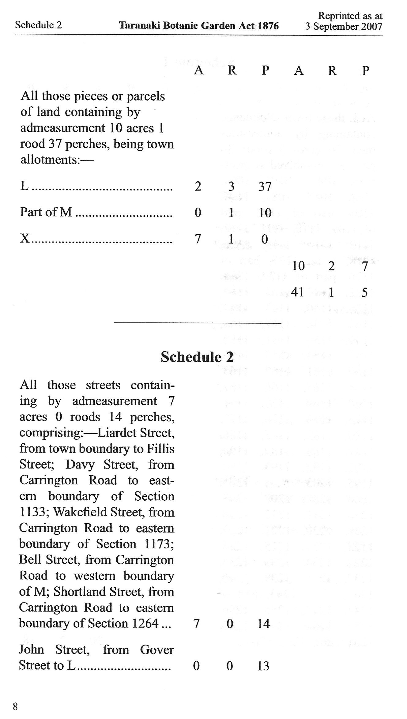
As well as numbered town sections the Board was also given areas marked “L” and “X” and part of “M” plus the areas of the streets within the boundary. These are all detailed in the Taranaki Botanical Garden Act 1876.
Other sections, such as 1182 and 1064 which are outside of the current boundary were part of the original quota but were released, usually as part of a land swap.
Changes to the Recreation Ground area. Purchases, swaps and donations:
1876 Section 1172 purchased for £62 14s from Mr. Stephenson.
1876 Section 1175 purchased for £50 from Mr. Hammerton.
1886 Section 1086 purchased for £40 from Mr. Dorsett.
1891 Sections 1107, 1108, 1127 and 1128 also part sections 1106, 1109, 1126 and 1129 purchased for £125 from Mrs Harriet Fookes. This block of land was originally known as Māori Reserve No 12.
1893 Section 1084 purchased for £25 plus a piece of land. Bought from Mr. Dingle. The piece of land exchanged was possibly section 1064.
1894 Section 1135 purchased for £16 16s from Reginald Bayley.
1899 Section 1182 transferred to Jockey Club as part of a land swap for the 3.5 acres below.
1901 3.5 acre block of land to the east of the Serpentine was transferred to the Recreation Ground from the Jockey Club. This area is Section D part 4 Sub1 – 3.2.0.
1917 Section of Holsworthy Road at southern boundary of Park transferred to Park.
1922 Section 1117 on Fillis Street purchased (Kindergarten plot).
1965 Section 1196 transferred from the estate of Harry Frethey.
Brooklands/ Maranui Gully Land Acquisitions

Brooklands and the Maranui Gully is a collection of parcels of land most of which were gifted to the town. The first parcels donated were from the Brooklands estate of the late Newton King, an area of over 53 acres. This prompted Messrs. List and Wilkinson to gift approximately 9 acres of the adjoining Maranui Gully. (* Although this was gifted in 1934 it was not officially part of Pukekura Park until 1944.) Mr. List had promised to gift a second plot which was part of the list garden, once his wife had decided she could no longer look after the land. It would seem that with the outbreak of war getting help was difficult prompting her to hand over the land (plot C on above map). To access this land from List Street the Council purchased a small area (plot D on above map) from the List estate.
The other significant parcel of land is the plot marked F on the above map. This was acquired from the Education Board in 2005. It had been part of the Highlands Intermediate grounds.
Parcels of land gifted to the town by the Newton King estate in 1933. The total area being 55 acres, 2 roods and 25.12 perches. Collection of Puke Ariki (Ref: ARC 2014-042).
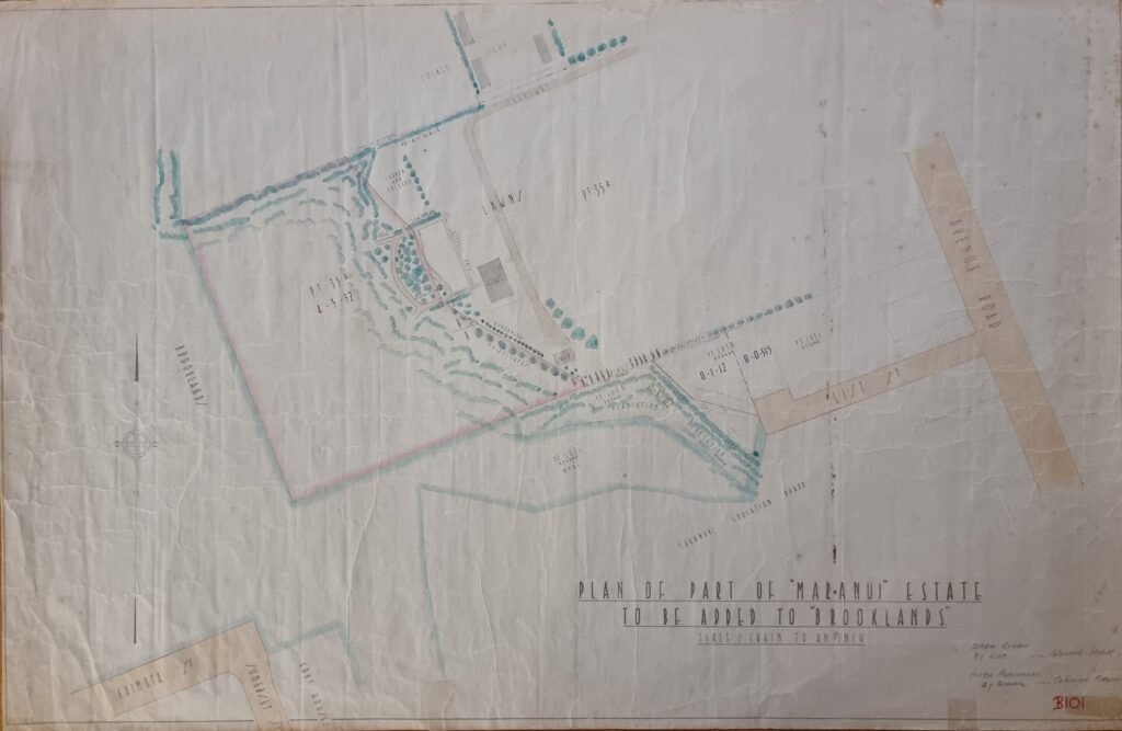
Parcels of land acquired from the List estate in 1944. The larger section being 4 acres, 3 roods and 32 perches was part of the List garden that had been promised by Mr. List when his wife could no longer look after it. The smaller section being slightly over 3 roods in area was purchased by the council for £100 from the List estate. Collection of Puke Ariki (Ref: ARC2014-043).